Our Curriculum Intent
At Hodge Clough Primary School, we aim to inspire children’s curiosity and fascination about the world and its people.
We believe in encouraging all children to develop a greater understanding and knowledge of the world, as well as their place in it. This will instil a passion and interest for the subject overall, providing children with the key knowledge, skills and vocabulary needed to be confident geographers.
Learning is linked to a range of topics and the children will have opportunities to investigate places, investigate patterns and communicate geographically. They will build on their prior learning and revisit these areas regularly, allowing them to remember more, know more and understand more.
Children at Hodge Clough will develop an excellent knowledge of where places are and what they are like, using geography to provoke and provide answers to questions about the natural and human aspects of the world.
We see exploring geography within the context of the immediate and wider local area as highly valuable and our children will be provided with the chance to explore the geography of their locality.
We are committed to providing them with opportunities to investigate and make enquiries about their local area of Moorside and Oldham so that they can develop a real sense of who they are and what makes their local area unique.
Our geography topics have been chosen to allow children to develop their knowledge and understanding of both the geography of our local area and the wider world.
Curriculum Overview
|
Autumn 1 |
Autumn 2 |
Spring 1 |
Spring 2 |
Summer 1 |
Summer 2 |
|||
|
Nur |
My home |
School community & My journey to school |
Different places in My World |
|||||
|
Rec |
My home (Address) |
School community & My journey to school (map) |
Different places in The World |
|||||
|
Year 1 |
Moorside & Oldham |
The United Kingdom |
Weather |
|||||
|
Year 2 |
London |
|
What would it be like to live in Nairobi, Kenya? |
Around the World (Continents & Oceans/ Hot & Cold places) |
||||
|
Year 3 |
Counties and Cities of the UK: region NW England |
Extreme Earth (Earthquakes and Volcanoes) |
Land use |
|||||
|
Year 4 |
Europe: Countries and capitals |
Rivers & Mountains The Water Cycle |
South Aegean region (European) |
|||||
|
Year 5 |
Somewhere to settle (settlements) |
Rainforests |
Brazil (S. America) |
|||||
|
Year 6 |
Biomes & Climate zones |
Economic Activity |
World Time Zones |
|||||
This is what our children should remember and be able to do in Geography by the end of EYFS.
|
ELG |
|
|
Understanding the World (People and Communities) |
Know that there are different countries in the world and talk about the differences they have experienced or seen in photographs. |
|
Recognise some environments that are different from the one in which they live. |
|
|
Recognise some similarities and differences between life in this country and life in other countries. |
|
|
Draw information from a simple map. |
|
|
Understanding the World (The Natural World) |
Explain some similarities and differences between the natural world around them and contrasting environments (life in this country and life in other countries). |
|
Describe their own immediate environment and how environments might vary from one another. |
|
|
Knowledge to be learned and retained |
|
|
Nursery |
|
|
|
|
Reception |
|
|
|
This is what our children should remember and be able to do in Geography by the end of Key Stage 1, including the previous objectives from EYFS.
Y1 Y2
|
N C objectives |
|
|
Locational Knowledge Name, locate and identify characteristics of the four countries and capital cities of the United Kingdom and its surrounding seas. (Y1) Name and locate the world’s 7 continents and 5 oceans. (Y2) |
Human and Physical geography Identify seasonal and daily weather patterns in the United Kingdom (Y1) and the location of hot and cold areas of the world in relation to the Equator and the North and South Poles. (Y2) Use basic geographical vocabulary to refer to:* Key Physical features, including: beach, cliff, coast, forest, hill,mountain, sea, ocean, river, soil, valley, vegetation, season and weather. * Key Human features, including: city, town, village, factory, farm, house, office, port, canal, harbour and shop. |
|
Place Knowledge Understand geographical similarities and differences through studying the human and physical geography of a small area of the United Kingdom, (Y1) ) and of a small area in a contrasting non-European country. (Y2) |
Skills and Fieldwork Use world maps, atlases and globes to identify the United Kingdom and its countries, (Y1) as well as the countries, continents and oceans studied at this key stage (Y2) Use simple compass directions (North, South, East and West) and locational and directional language (e.g. near / far, left / right) to describe the location of features and routes on a map. (Y1/2) Use aerial photographs and plan perspectives to recognise landmarks and basic human and physical features; (Y1) (Y2) devise a simple map; and use and construct basic symbols in a key. (Y1) (Y2) Use simple fieldwork and observational skills to study the geography of their school and its grounds and the key human and physical features of its surrounding environment. (Y1) (Y2) |
|
Knowledge to be learned and retained |
|
|
Year 1 |
|
|
|
|
Year 2 |
|
|
|
This is what our children should remember and be able to do in Geography by the end of Key Stage 2, including the previous objectives from EYFS & KS1.
Y3 Y4 Y5 Y6
|
N C objectives |
|
|
Locational Knowledge Locate the world’s countries, using maps to focus on Europe (inc. the location of Russia) and North and South America, concentrating on their environmental regions, key physical and human characteristics, countries, and major cities. (Y4) (Y5) Name and locate counties and cities of the United Kingdom, geographical regions and their identifying human and physical characteristics, key topographical features (inc. hills, mountains, coasts and rivers), and land-use patterns; and understand how some of these aspects have changed over time. (Y3) Identify the position and significance of latitude, longitude, Equator, Northern Hemisphere, Southern Hemisphere, the Trips of Cancer and Capricorn, Arctic and Antarctic circle, (Y5) the Prime / Greenwich Meridian and time zones (inc. day and night). (Y6) |
Human and Physical geography Describe and understand key aspects of: *physical geography, including: climate zones, biomes and vegetation belts (Y5/6),rivers, mountains, the water cycle (Y4) volcanoes and earthquakes (Y3); *human geography, including: types of settlement and land use, (Y3/5) economic activity including trade links, and the distribution of natural resources including energy, food, minerals and water (Y6) |
|
Place Knowledge Understand geographical similarities and differences through the study of human and physical geography of a region of the United Kingdom, (Y3) a region in a European country (Y4), and a region within North or South America. (Y5) |
Skills and Fieldwork Use maps, atlases, globes and digital/computer mapping to locate countries (Y3-6) and describe features studied; Use the eight points of a compass (Y3-6) four and six-figure grid references, symbols and key (including the use of Ordnance Survey maps) to build their knowledge of the United Kingdom and the wider world; Use fieldwork to observe, measure, record and present the human and physical features in the local area using a range of methods, including sketch maps, plans and graphs, and digital technologies. |
|
Knowledge to be learned and retained |
|
|
Year 3 |
|
|
|
|
Year 4 |
|
|
|
|
Year 5 |
|
|
|
|
Year 6 |
|
|
|
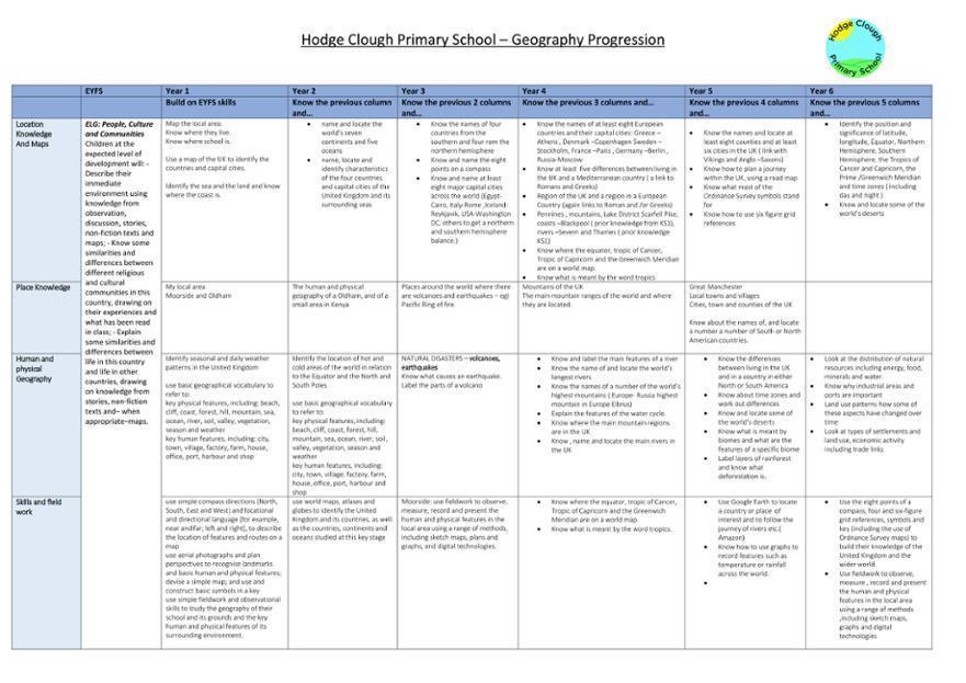
We follow the National Curriculum for Geography. Please use the link for more information.


|
Geography Progression and Knowledge- completed Aug 24 | [docx 43KB] |

|
Our Curriculum Map 24/25
|
|
Geography Curriculum overview | [docx 313KB] |
|
Geography Progression of Skills/Knowledge